Perch Creek
Ontario, Canada
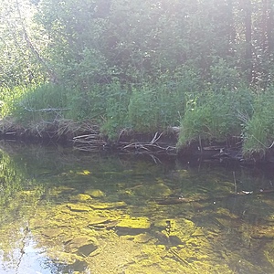
Wider section of Perch Creek, downstream of Perch Lake and a number of ranches. Testing takes place just downstream of the bridge at Doyle Road. This is a roadside site. The water is tested close to a riffle area in the stream.
This site has been tested by trained community scientists since 2015.

Location created by
Couchiching Conservancy
- Group: Couchiching Conservancy : Community Science Water Monitoring Program
- Site ID: WQ03
- Lat: 44.6398494
- Lng: -78.9228415
- Waterbody Type: Creek
- Timezone: America/Toronto
Latest photos
View all photosObservations summary
Observation tests summary
Air temperature
°C
16.0
Latest
15.3
Average
Water temperature
°C
11.5
Latest
10.7
Average
Alkalinity
mg/L
196
Latest
188
Average
Nitrates
mg/L
0.0
Latest
0.0
Average
Dissolved oxygen
mg/L
5.8
Latest
6.6
Average
Phosphates total
ppm
0.0
Latest
0.0
Average
Turbidity
JTU
0
Latest
0
Average
pH (0-14)
7.0
Latest
7.2
Average
Water depth
m
0.7
Latest
0.6
Average
Chloride
ppm
36.0
Latest
19.1
Average

