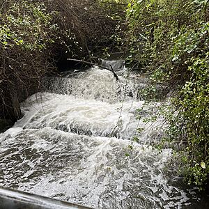
Wagg Creek at footbridge below sedimentation pond - WAG-M-03 Medium Priority
North Vancouver, British Columbia, Canada
WAG-M-03 WAG Creek at footbridge below the sedimentation pond at the fish ladder. CNV City Map CNV City Map -123.0777490, 49.32733712 Long and Lat, or UTM 494,351E, 5,463,848N. Identical to Salt Project site "Wagg Creek Fish Ladder and Pond at Mahon St". Merge data into this new location or archive old data?

Location created by
Paul Lhotka
- Site ID: WAG-M-03
- Lat: 49.3272058
- Lng: -123.0778384
- Waterbody Type: Creek
- Timezone: America/Vancouver
Latest photos
View all photosObservations summary
Observation tests summary
Air temperature
°C
17.6
Latest
14.3
Average
Water temperature
°C
15.6
Latest
13.1
Average
Alkalinity
mg/L
20
Latest
57
Average
Hardness
mg/L
0
Latest
33
Average
Chlorine
ppm
0.0
Latest
0.1
Average
Conductivity
μS/cm
307
Latest
289
Average
pH (0-14)
7.4
Latest
7.1
Average
Water depth
m
0.1
Latest
0.1
Average
Dissolved oxygen
mg/L
7.0
Latest
6.1
Average
Turbidity
NTU
14.0
Latest
16.3
Average
Ice On
Ice Off
- 2022-10-11
- 2022-08-04

