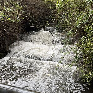
Wagg Creek at footbridge below sedimentation pond - WAG-M-03 Medium Priority
North Vancouver, British Columbia, Canada
WAG-M-03 WAG Creek at footbridge below the sedimentation pond at the fish ladder. CNV City Map CNV City Map -123.0777490, 49.32733712 Long and Lat, or UTM 494,351E, 5,463,848N. Identical to Salt Project site "Wagg Creek Fish Ladder and Pond at Mahon St". Merge data into this new location or archive old data?

- Site ID: WAG-M-03
- Lat: 49.3272058
- Lng: -123.0778384
- Waterbody Type: Creek
- Timezone: America/Vancouver
Latest photos
View all photosWagg Creek at footbridge below sedimentation pond - WAG-M-03 Medium Priority : WAG-M-03
Observed on
2025-07-20
Crayfish and stickleback observed. Turbidity < 14 NTU. ALS Global sampling 6PPD and Q
Wagg Creek at footbridge below sedimentation pond - WAG-M-03 Medium Priority : WAG-M-03
Observed on
2025-01-15
Turb < 14 No flows done
Wagg Creek at footbridge below sedimentation pond - WAG-M-03 Medium Priority : WAG-M-03
Observed on
2024-11-28
Turbidity <14 Looking very clear today
Wagg Creek at footbridge below sedimentation pond - WAG-M-03 Medium Priority : WAG-M-03
Observed on
2024-11-09
Turbidity less than 14. Tested due to Paul's report of blackish water downstream at 10:20. Bla...
Wagg Creek at footbridge below sedimentation pond - WAG-M-03 Medium Priority : WAG-M-03
Observed on
2024-11-08
Turbidity <14
Wagg Creek at footbridge below sedimentation pond - WAG-M-03 Medium Priority : WAG-M-03
Observed on
2024-11-07
Turbidity <14
Wagg Creek at footbridge below sedimentation pond - WAG-M-03 Medium Priority : WAG-M-03
Observed on
2024-10-14
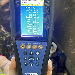
Turbidity less than 14 YSI simultaneous measurements
Wagg Creek at footbridge below sedimentation pond - WAG-M-03 Medium Priority : WAG-M-03
Observed on
2024-10-04
Did not sample oxygen this morning, couldn't safely get closer than the edge due to strength of f...
Wagg Creek at footbridge below sedimentation pond - WAG-M-03 Medium Priority : WAG-M-03
Observed on
2024-10-03
Less than 14
Wagg Creek at footbridge below sedimentation pond - WAG-M-03 Medium Priority : WAG-M-03
Observed on
2024-09-25


