Pearl River
Jackson, Mississippi, United States
Byram Swinging Bridge connects Hinds and Rankin counties over the Pearl River. It was added to the National Register of Historic Places in 1979. Access the river from the west (Byram) side and sample just north of the bridge. River bank is sandy but hard-packed clay near the water's edge can be slippery.

- Group: Mississippi State University : Mississippi Water Stewards
- Site ID: BSB
- Lat: 32.1765387
- Lng: -90.2435446
- Waterbody Type: River
- Timezone: America/Chicago
Latest photos
View all photosWater had a greenish brown color. The river has suffered recent large urban sewage spills and bacterial counts are improved over last month.
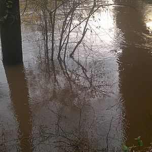
Water had a muddy appearance due to recent rains and high water over the past month. Upstream sewage contamination continues to be severe with public notices to avoid contact remaining in effect for many years.
Urban contamination suspected but not confirmed, due to recent heavy rains, and water treatment deficiencies.
The river stage is falling, but still about four feet higher than usual, and still receding from recent heavy rains. Lots of human traffic is observed on the scenic old bridge.
Water has brownish/Green tint, and water clarity is low. Several people observed having their lunch along both banks.
Evidence of recent bank fishing, and river was up approx. two feet from last check. Although water still had a muddy, brown appearance, it appeared to have less suspended particulate matter.
Gentle current today, water had slightly more clarity today than last week.
River Stage in Jackson 3.58; River has brownish/greenish color with fine, suspended sediment noted. Gentle and slow river current also noted. Evidence of recent fishing activity at this location.
River gauge 3.9ft in Jackson and steady after falling several feet after heavy rains in the past two weeks. Samples taken today on the east side of the river due to west bank inaccessible.
Current river stage at Jackson was 16.1. Due to recent heavy rain and flooding, the river was up over 10ft, very swift, and more than double the usual volume of water flowing past this test site. The water had a brown, muddy appearance, and noticeably different from its usual clearer nature. No wildlife observed, but several people stopped to have lunch on the bridge, and two canoeists were observed.


