McGee Creek
Ontario, Canada
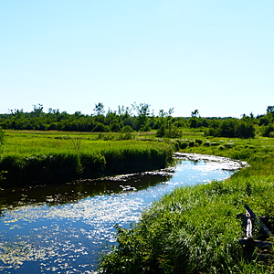
A wide, slow-moving section of McGee Creek before it flows into Canal Lake. Testing site is down the bank from Centennial Park Road, just beside the bridge over the creek.

- Group: Couchiching Conservancy : Community Science Water Monitoring Program
- Site ID: WQ10
- Lat: 44.5961208
- Lng: -79.0476608
- Waterbody Type: Creek
- Timezone: America/Toronto
Latest photos
View all photosMcGee Creek : McGee Creek at Centennial Park Road
Observed on
2018-12-07
Site and significant stretch up and downstream completely frozen over. Water level is high, signi...
McGee Creek : McGee Creek at Centennial Park Road
Observed on
2018-10-26
Cool, rainy previous day. Rained during testing. Milkweed pods have opened completely.
McGee Creek : McGee Creek at Centennial Park Road
Observed on
2018-10-01
Unseasonably cool, light rain previous day. Milkweed pods are opening. Nuthatch heard calling. Ra...
McGee Creek : McGee Creek at Centennial Park Road
Observed on
2018-08-24
Heavy rain in the past 48 hours. Damselflies, great spangled fritillary, monarch, cabbage white a...
McGee Creek : McGee Creek at Centennial Park Road
Observed on
2018-07-08
Testing was carried out with a LaMotte Environmental Educator kit. Emerald Shiners and Blacknose ...
McGee Creek : McGee Creek at Centennial Park Road
Observed on
2018-06-09
Testing carried out using a LaMotte Environmental Educator field kit. Several Emerald Shiners wer...


