Bolivar Creek
British Columbia, Canada
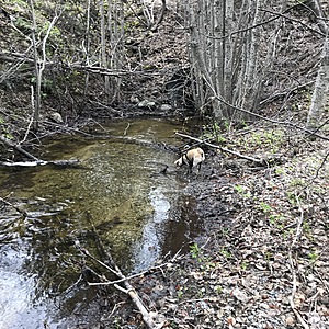
The high side of a FSR, this creek collects in a small pond at the base of a hill before running into a culvert under the road. This area is mostly shaded. We collected water from the downstream side of the pond.
There is visible sign of cattle in the area, tracks and patties. The pond/stream area we tested is not directly accessible by cattle but the hillside above it is.

Location created by
Livia DiGirolamo
- Lat: 49.7916683
- Lng: -119.9445033
- Waterbody Type: Creek
- Timezone: America/Vancouver
Latest photos
Observation tests summary
Air temperature
°C
12.0
Latest
12.0
Average
Water temperature
°C
4.9
Latest
4.9
Average
Alkalinity
mg/L
100
Latest
100
Average
Hardness
mg/L
150
Latest
150
Average
Dissolved oxygen
mg/L
6.0
Latest
6.0
Average
Conductivity
μS/cm
240
Latest
240
Average
Secchi depth
m
0.0
Latest
0.0
Average
Water depth
m
0.2
Latest
0.2
Average
pH (0-14)
7.8
Latest
7.8
Average
