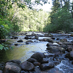
Coquitlam River
Coquitlam, British Columbia, Canada
Off East side of Pipeline Rd. at BMX Competitions; Upper Coquitlam River and past quarries; and cement companies. Uneven rock bottoms with seasonally low water due to less release by BC Hydro from dam of Coquitlam Lake that is part of the Coqquitlam Watershed and Tri-City water source.

Location created by
Nancy Gail Klassen
- Group: Water Rangers : Equipping communities in data-deficient areas
- Site ID: 49.328334, -122.7722845
- Lat: 49.3291754
- Lng: -122.7720244
- Waterbody Type: River
- Timezone: America/Vancouver
Latest photos
View all photosObservation tests summary
Air temperature
°C
12.5
Latest
16.0
Average
Water temperature
°C
13.5
Latest
14.8
Average
Alkalinity
mg/L
0
Latest
3
Average
Hardness
mg/L
0
Latest
1
Average
Dissolved oxygen
mg/L
7.0
Latest
7.4
Average
Chlorine
ppm
0.0
Latest
0.0
Average
Conductivity
μS/cm
0
Latest
0
Average
Secchi depth
m
0.0
Latest
0.0
Average
Water depth
m
0.2
Latest
0.2
Average
pH (0-14)
6.4
Latest
6.3
Average

