Bourbonnais Creek
Bourbonnais, Illinois, United States
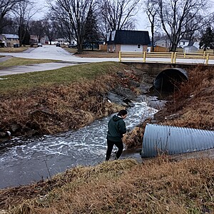
Water flowing through a structured channel with culverts under the roads. Minimal dangers include the somewhat steep banks, the nearby roads, & slippery rocks.

- Group: Water Rangers : Water Rangers Water Quality Testers
- Site ID: BourbCreek-01
- Lat: 41.1515643
- Lng: -87.8803468
- Waterbody Type: Creek
- Timezone: America/Chicago
Latest photos
View all photosBourbonnais Creek : Bourbonnais Creek Upstream
Observed on
2025-02-23
Signifigant melting of ice on the creek. Very sunny and temperature is much warmer.
Bourbonnais Creek : Bourbonnais Creek Upstream
Observed on
2025-02-22
Bourbonnais Creek : Bourbonnais Creek Upstream
Observed on
2025-02-20
Bourbonnais Creek : Bourbonnais Creek Upstream
Observed on
2025-02-15
Quantab units reached 9.4 on the high-value tabs, indicating that the Cl- value is greater than 6...
Bourbonnais Creek : Bourbonnais Creek Upstream
Observed on
2025-02-14
Measurement is actually 6852+ ppm Cl-, but the field doesn't allow or a higher measurement than 5...
Bourbonnais Creek : Bourbonnais Creek Upstream
Observed on
2025-02-08
Bourbonnais Creek : Bourbonnais Creek Upstream
Observed on
2025-02-05
Coldfront approaching with snow on the forecast tonight. Lots of salt just put down on the roads.
Bourbonnais Creek : Bourbonnais Creek Upstream
Observed on
2025-01-31
almost all the snow has melted, the creek completely thawed, fast water flow in creek and from dr...
Bourbonnais Creek : Bourbonnais Creek Upstream
Observed on
2025-01-30
Most snow has melted, lots of salt on ground, most of the creek is frozen, some areas are comple...


