
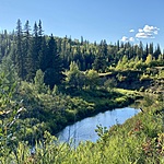
Tawatinaw River
Athabasca, Alberta, Canada
This location is North of the Highway 55 overpass and about 200 metres south of the confluence with the Athabasca River.
Location created by
Lisa Allan
- Group: Athabasca Watershed Council : Tawatinaw Watershed Working Group
- Lat: 54.7215097
- Lng: -113.279922
- Waterbody Type: River
- Timezone: America/Edmonton
Latest photos


Willows on the bank here are coming in slowly, but there is competition from grass and tansy. Could hear birds all around, but did not see them.
The testing site had a backward flow with high levels from the Athabasca pushing in. Upstream, the water level was much lower, indicative of the dry weather we have been having.
The Tawatinaw at this location is at its highest so far this year. It was pretty low, even a few weeks ago. There is backflow coming in from the Athabasca, which is also at its highest so far this year.
Water is very opaque.
There was a lot of garbage around the site!
The banks are starting to freeze up, and the water depth seems higher than last month.
The water level is very low. Some bubbles/foam on water.
The water level is very low. The shopping cart has been removed!
The water upstream was relatively clear. There was an earthy smell to the water.
There is a shopping cart just upstream from the tree. :-(
The Athabasca is high, so there is back flow from it moving upstream on the Tawatinaw. The water is still significantly lower compared to last year at this time.
The riparian plant growth looks good, with some of the planted willows looking better than they have in previous years.
We continue to see the Styrofoam ball pollution in the area. There is some gravel under the bridge washing out upstream from the site.
There was some brown scum collecting along the banks and at the tree in the river.
There is a pollution event occurring at this site and further upstream. There are small styrofoam balls littered along the banks. They are likely being washed downstream into the Athabasca when the water levels are high or there is heavy rain.
No evidence of wildlife at the site.
Low water levels. Some ice is still present under the bridge. Smell of manure. Water opaque. Can't see bottom. Estimate of 30cm for water depth.
The testing area has now frozen over. There is below-average snowpack in the area. The center channel of the Athabasca River is still open water.