
Pearl River
Brandon, Mississippi, United States
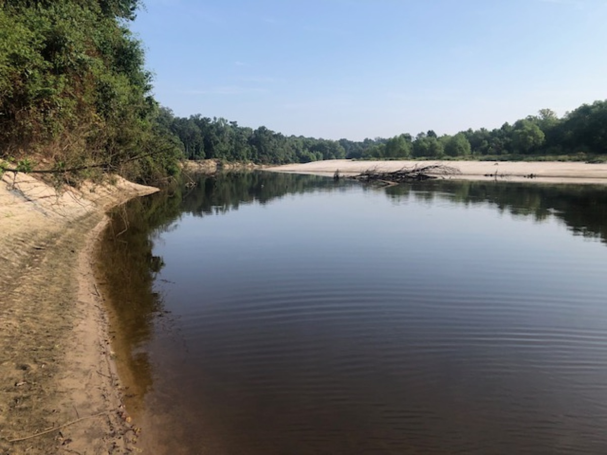
Site is on upstream edge of sandbar on right downstream bank of Pearl River located 0.25 miles south of the Lake Hico water intake tower on River. Site is upstream of confluence with Purple Creek. Access is from the east end of Westbrook Road. Westbrook Road ends at the open gate to the Westbrook family compound. Drive thru the open gate on the gravel road and continue straight. Gravel track will change to dirt track at 0.10 mile from gate where the gravel drive to the Westbrook family compound veers to left – continue straight. Park on side of track at bar gate located on
right side that leads to the Lake Hico water intake structure on the Pearl River. The trail or path to the sandbar begins here. Walk down the open access track to the Lake Hico intake structure. Continue straight past intake along trails thru the woods along and near the upper bank of the Pearl River. The distance is 0.4 miles from the parking site to the sandbar. Sample the river at the upstream edge of the sandbar. The Pearl River bank at the end of Westbrook Road is high and steep. If walking to the sandbar site is not desirable, alternative sampling sites are along the river downstream from the Lake Hico water intake structure, although the very steep river bank is ~ 15 – 25 feet in height in these areas. Jack Westbrook owns the property where parking is located and down the trails thru woodlands to the sandbar. Louise York lives nearby. The driveway to Ms. York’s house is the last gravel drive to the right just before the Westbrook gate. Ms. York contacted Mr. Westbrook about the desire of RiverKeepers to monitor the Pearl River at this location, and Mr. Westbrook approved.
Location created by
Abby Braman
- Group: Mississippi State University : Mississippi Water Stewards
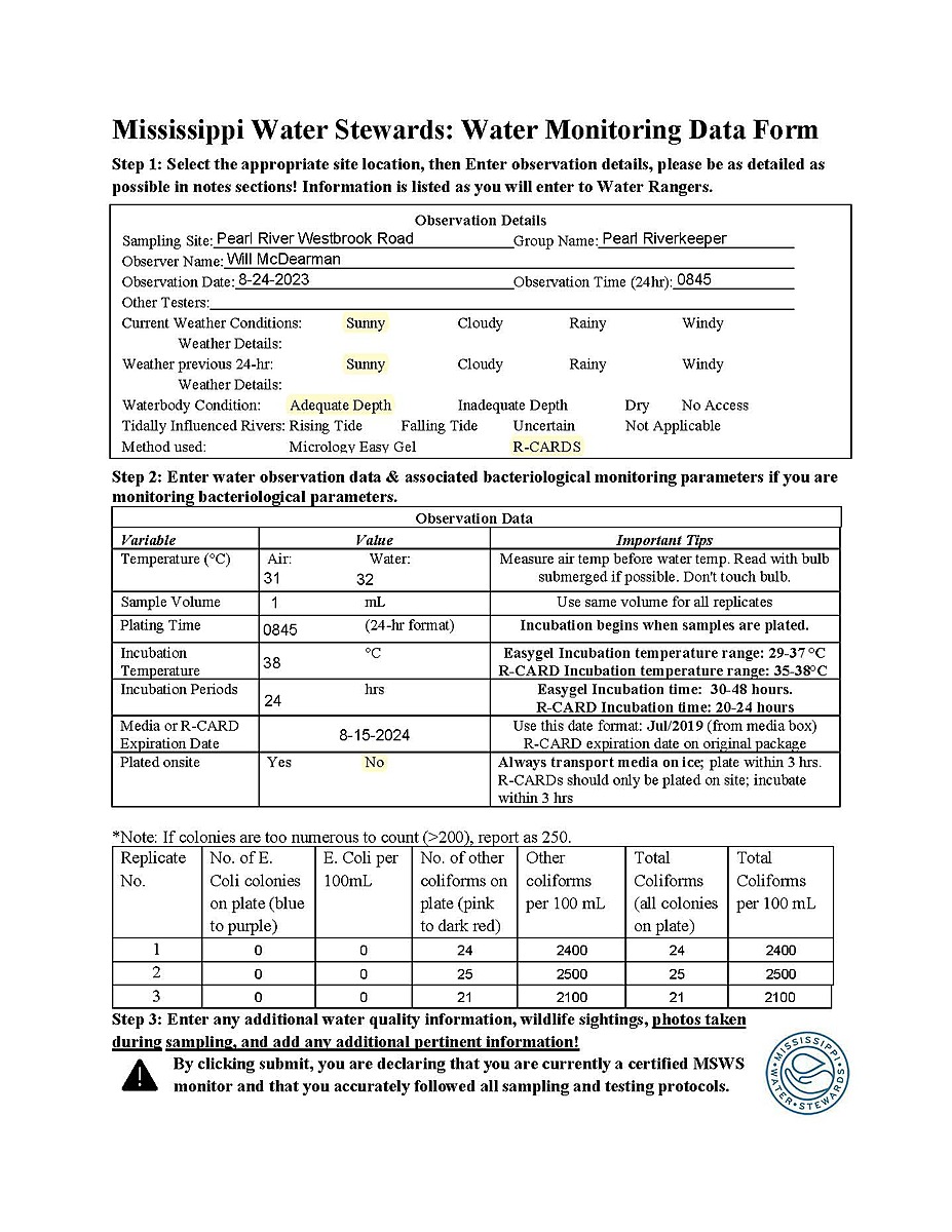
- Lat: 32.3650645
- Lng: -90.1007438
- Waterbody Type: River
- Timezone: America/Chicago
Latest photos
Stage from USGS gauge downstream at Hwy 25. River at typical low summer stage, with little current and flow. Test site located about 300 upstream from regular test site due to time constraints. Alternative site is equivalent to regular site.
typically low summer river stage, very low flow, not and dry, high temps at 100-102 last 2 weeks . 16.5' at USGS Hwy 25 gauge downriver.
River on slow long fall from higher stage 7 days earlier, now at 16.3' at USGS Hwy 25 gauge downriver.
river stage still up slightly from typical low summer flow, at 18.4' from USGS downstream Hwy 25 Lakeland gauge, from reservoir discharge.
River up and access blocked by flooding to regular test site. Stage is 25.5' at downstream USGS Hwy 25 Lakeland Drive gauge. Alternate site is considered equivalent to regular site. Alternative site is about 600 feet upstream from regular site.
River up from recent rain and spillway release, at 19.1' on USGS downstream gauge at Hwy 25, though falling from earlier high of 20.9' 12 hours earlier.
river rising, stage up from recent rains and upstream reservoir spillway releases, 19.5' on USGS Hwy 25 downstream gauge.
River has dropped significantly from flood of the previous week at a flood stage of 33.2' at USGS Hwy 25- Lakeland Driver downstream gauge. Current stage 19.5'
Pearl River at flood stage, 32.1' at downstream USGS Hwy 25 gauge. Test site not accessible, but this test taken from high river bank about 700 feet upstream of regular site, considered representative and equivalent to regular site. This alternative site is not available during normal river stages because of the steep vertical slope from high river bank to river edge.
very low flow, stage gauge USGS Hwy 25 downstream