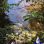
Madrona Creek
British Columbia, Canada
Location created by
SSIFWC Project
- Group: Salt Spring Island Water Preservation Society (SSI WPS) : Salt Spring Island FreshWater Catalogue (SSIFWC) Project
- Lat: 48.871
- Lng: -123.517
- Waterbody Type: Creek
- Timezone: UTC
Latest photos
No photos uploaded.
This is the highest Intake sampled for this Creek.
Pond has not been receiving water for some time - ph and temp showing a stag tion-
Culvert is receiving water from above (north side) the road / owner is saying this is the groundwater also feeding his well.