Strong River
D Lo, Mississippi, United States
D'Lo Water Park

- Group: Mississippi State University : Mississippi Water Stewards
- Lat: 31.9806876
- Lng: -89.8965311
- Waterbody Type: River
- Timezone: America/Chicago
Latest photos
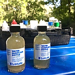
View all photosStrong River begins in the Bienville National Forest near Morton and flows southwest past Pucket and Mendenhall before joining the Pearl River. It's drainage area is 425 sq. miles. Today's test results show an extremely high level of e coli, i.e. 8000 per 100 ml.
Some possible sources of fecal contamination include; agricultural runoff, wildlife that use the water as their natural habitat, runoff from areas contaminated with pet manure, wastewater treatment plants, and on-site septic systems. Heavy precipitation may cause these organisms to be washed into creeks, rivers, streams, lakes, or ground water.
Due to recent rains, water levels were high (21ft) which is well above normal stage. Minor flooding begins at 25 ft. Both Merit and D'Lo water parks were closed to the public. The river is dangerous (cfs 6,000) and better left to skilled kayakers or canoeists whose craft are supported by flotation bags.


