Muskrat Lake Watershed
Ontario, Canada
UPPER STOQUA CK ABOVE CONTROLLED TILE DRAIN INSTALLATION

- Group: Water Rangers : Explorer's team
- Lat: 45.6602321
- Lng: -76.9869057
- Waterbody Type: Lake
- Timezone: America/Toronto
Latest photos
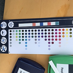
View all photosSample collected as part of Algonquin College Research Project on biological remediation of nutrients - mainly Phosphorus loading
Algonquin College water quality research site, Tim Egan is the property owner and has a full time corn production fields adjacent to this creek.
Upper Stoqua Creek.
Samples taken by the EXOVA and uploaded to add a baseline.
Wind 5km S, Cloud cover 25%, Trickling flow from tile drain, pre CTD installation, heavy rainfall event last weekend.
344360 E, 5058196 N - NTUs
Station data record
Upper Stoqua Creek.
Samples taken by the EXOVA and uploaded to add a baseline.
Macrophyte 45%, Periphyton (1-5) : 1
Wind 5km NW, Cloud cover 5%, Sunny, Field cut, baling today, minnows
344360 E, 5058196 N - NTUs
Station data record
Upper Stoqua Creek.
Samples taken by the EXOVA and uploaded to add a baseline.
Macrophyte 5%, Periphyton (1-5) : 1
Wind 5km E, Cloud cover 100%, Heavy rain. Mint smell from grass.
344360 E, 5058196 N - NTUs
Station data record
Upper Stoqua Creek.
Samples taken by the EXOVA and uploaded to add a baseline.
Macrophyte 15%, Periphyton (1-5) : 1
Wind 5km S, Cloud cover 70%, Sunny, heavy rainfall event weekend prior to sampling.
344360 E, 5058196 N - NTUs
Station data record
Upper Stoqua Creek.
Samples taken by the EXOVA and uploaded to add a baseline.
Wind 15km NW, Cloud cover 5%, Sunny, No Discharge/flow from tile drain upstream from sample site.
344360 E, 5058196 N - NTUs
Station data record

