Natural Wey River (Unstead)
Godalming, Surrey, United Kingdom
Natural river close to bridge, which is accessible from the road. Tree lined, shaded, fallen tree in river. Upstream from Godalming Sewerage Treatment Works.

- Group: River Wey Trust : Godalming Hub
- Lat: 51.2001746
- Lng: -0.5806231
- Waterbody Type: River
- Timezone: Europe/London
Latest photos
Water level high but below the riverbank. Heavy rain/storm overnight.
Heavy rain in recent days
The river is low, you can almost see the bottom of the river bed. I think the cattle in the adjoining field may have been moved.
Cattle have been moved into this field so are likely to be accessing the river for drinking water where the riverbank is low enough.
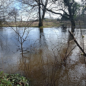
River level high. Water entering water meadow to the east and to a lesser extent the west side of the river.
The river was at its highest level since I started testing. The water has come over the far(eastern) bank. Yesterday there was persistent rainfall for much of the day.
Tree still fallen across part of the river downstream.
There was a heavy downpour before testing. The river was flowing quicker and was higher than it has been during recent testing. There is a tree leaning into the river. There are now cattle in the field on west side of the natural river.
Bough of willow tree leaning over into the river
The location is shaded by trees. The fallen tree has slowed down the flow of water at the point of testing. The river is moving more quickly in the middle/other side of the river bank. This side of the river is grazed often by cattle although we did not see any today. The cattle tend to access the water for drinking further downstream. This land is owned by The National Trust.
