Lake Erie
Sparta, Ontario, Canada
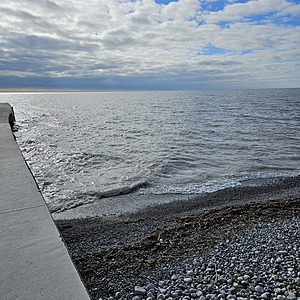
Tested from the side of the pier facing navigational water marker EB2 - same place as the first time I tested in June, but this time I attempted to use the app to pinpoint my exact location as I plan to always test in the same place.

- Group: Thames Blue Water Metis Council - Citizen monitoring program
- Lat: 42.6536651
- Lng: -81.00919
- Waterbody Type: Lake
- Timezone: America/Toronto
Latest photos
View all photosPeople fishing from pier stated they were getting nibbles but no bites. Lots of people walking beach. No boats observed. Water looked murky overall but was clear when collected for testing.
Unable to test from my usual spot. Pier was covered with debris & ice pile. Water was low and too rough on one side of the pier/beach. Too dangerous to enter to collect a sample. I sampled water from the calm side of the pier at the mouth of the channel leading out to the lake. My spouse commented on the green tinge of the water but we are unsure if it was algae. I did a double take on the water temp but don't know if that's normal for February or not. Will calibrate pen before testing in March.
No one using pier when I arrived. No boats observed in water or debris in water. Birds were on a break wall opposite of pier that helps form channel. Not much wave action for Erie and water appeared murky. People were walking the shore on the beach side.
When I arrived, no one on pier, no one fishing, and no boats observed on water. People walking on beach side. Very little wave action but steady flow. Water level was so low, I had to stretch to collect it. Lowest yet since I started testing.
Very windy with rough brown murky water. Lots of birds on the pier and some in the water. Could see pieces of wood being churned in the waves. No boats in the area. One person fishing at the end of the pier on opposite side of testing area (facing the beach). I test the channel side.
Few people fishing on pier, not having any luck. People swimming at the beach area. Several boats close by and seemed to be heading in as wind was picking up. Sample taken prior to boats passing by to enter channel.
I did testing a few days earlier than the actual scheduled testing weekend because I won't be in the area on the days we are supposed to test next.
Boats were coming in & out of the channel, so that would be source of "other" pollution. Folks were fishing from pier and people were swimming on other side of the pier/channel at the beach. (The beach was determined to be safe to swim at by the Health Unit on July 19th).
Water appeared green but I couldn't tell if there was any algae.
Quite a few people fishing from the pier & observed a few boats heading out from the channel into open water. I noted the boats would be an "other" pollution source. The folks fishing advised they weren't getting any bites and fishing appeared to go flat about four days prior. The beach on the other side of the pier is frequented by dogs.


