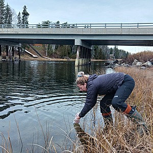
Hawk Lake
Ontario, Canada
Hake Lake boat launch.

- Group: Missanabie Cree First Nation : Dog Lake Head Waters Monitoring Program
- Site ID: HL-WM-D
- Lat: 48.080144
- Lng: -84.5518761
- Waterbody Type: Lake
- Timezone: UTC
Latest photos
View all photosBeaver dam
Natural wood dams
Birds
Caterpillar
Dragonfly
Fish jumped well taking sample
Heard a woodpecker
Fiddle heads other fresh vegetation
- Salinity was 72 ppm on the shore line and 83.0 ppm under the bridge
- Obtained a vertebrate eDNA Sample (fish) 7 pulls totaling 235 mL (See Photos)
This testing location is at the intersection of McVeigh Creek and Hawk Lake. McVeigh Creek is the headwater of Hawk Lake, which is affected by historic iron mines to the north. Alamos Gold's Island Gold District Mine is now present on the shores of McVeigh Creek and has obligations for remediation of the historic iron mines which has had an effect on the quality of water downstream.
Did not measure water depth or do secchi reading.
Entered by T.Hourtovenko, from results that were obtained by T. Sullivan (previous director of Land & Resources)
Suspect that ph strips were expired as results obtained by T. Sullivan are not consistent with recent results and certain strip containers were found to be expired during inventory process.
data entered on behalf of Micheal Tremblay, Water Guardian in 2022.
uploaded on behalf of water sampler, Michael Tremblay


